


GPS-equipped outdoor watches are becoming an essential piece of gear for sports and outdoor activities. They are constantly evolving, not only providing ABC (altitude, barometric pressure, and direction) functions, but also being able to track your current location and display maps offline
Among these GPS outdoor watches, there are three representative models designed for use on mountain climbs: the CASIO PRO TREK Smart WSD-F20 , the GARMIN fenix 5x Sapphire , and the EPSON Wristable GPS for Trek MZ-500. In this project, we'll compare them all on actual mountain climbs to see what makes each model tick, as well as their strengths and weaknesses. In this second part, we'll compare them on a day hike to see what they can do and to what extent. We hope this will be helpful to anyone who is currently undecided about whether to buy one.
If you would like to read the previous review summarizing the appearance and usability of the hardware, please see the page below
- Buying Guide: CASIO, GARMIN, and EPSON: Finding the Best GPS Outdoor Watch for Your Purpose [Part 1]
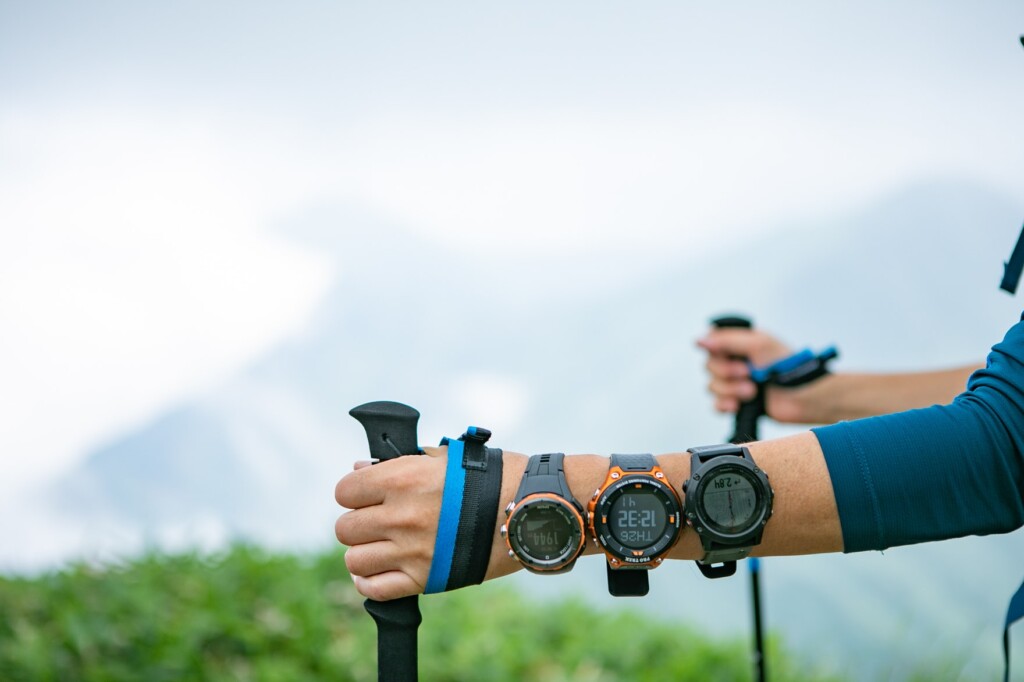
table of contents
table of contents
- Items tested and test environment ( Part 1 )
- Detailed comparison review (Part 1reference)
- Summary - What are the recommendations by type? - (Page 2)
- [Reference] Specs and function comparison table
Detailed Comparison Review (Part 2)
6. Functionality and what you can do
We'll compare the features of each model, or to put it simply, the types of things you can do with these watches. The three models compared here share the basic functions of checking the time, direction, altitude, and barometric pressure, as well as tracking your location via GPS. However, when you go into more detail, the features they can do vary greatly depending on their individual characteristics. Of course, none of these devices are designed just for mountain climbing, so the functions users are looking for will differ depending on their purpose, and impressions will vary from person to person, but this time we'll be comparing and evaluating them mainly based on the features related to mountain climbing and hiking
GARMIN - Powerful fitness support machine for athletes -
If you register your route before climbing, it will navigate you like a car navigation system
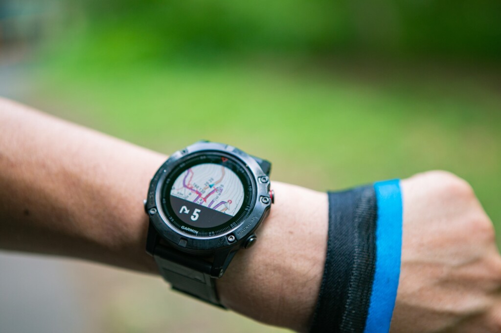
First of all, as expected, the fenix 5x 's feature richness and detail are unmatched. Frankly, there are far too many features to list here, so I'll just touch on the most important ones. As you'd expect from a flagship model, it supports a variety of activities, including hiking and trail running, as well as running, cycling, swimming, canoeing, fitness, and golf. It displays data measured by a variety of sensors, including an optical heart rate monitor, tailored to each activity. What's more, the display is highly customizable, allowing you to customize it to your liking. The watch comes with a fully pre-installed offline map, so you can always view it without having to download it in advance. By sending the GPX data of a hiking route you've created to the watch, it can function just like a car navigation system in the field (though in my experience using it on an actual hike, it's still more of a gamble, as it's not accurate enough to provide detailed navigation for every branch in the road). Syncing the watch with your smartphone also allows for timely notifications, calendar updates, weather forecasts, and incoming calls, making it a smartwatch-like experience.

You can obtain extremely detailed data that is useful for running
Furthermore, it not only records distance, time, and location information, but also temperature, heart rate changes, average pace, and calorie consumption in detail, and based on that, analyzes training effects, VO2 Max value (total body endurance and aerobic capacity), lactate threshold, and even predicted marathon times! The features for athletes are truly impressive. These can be viewed in the dedicated management app "Garmin Connect," and it also provides tips on training load, making it truly a must-have for anyone who wants to improve their records and maximize their performance in each activity
CASIO - Easy to use outdoors, just like a smartphone, and convenient for everyday use -
The base interface is easy to use, so if you have a good app, it becomes very easy to use
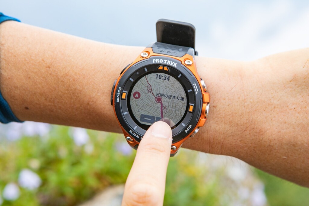
the WSD-F20 may not offer as many detailed features, it certainly does offer a wide range of functionality, including for everyday use . First and foremost, the ability to display clear offline maps (though they require prior download) is extremely useful considering this price range. It can display information for a wide range of activities, including not only trekking but also cycling, fishing, paddle sports, snow sports, surfing, and golf. For Japanese mountaineering in particular, the third-party app "YAMAP" is simply excellent. It initially had some instability, but now I find it extremely useful. While on-site, you can view 1:25,000 topographic maps from the Geospatial Information Authority of Japan, which include information like course times, offline (you need to transfer them beforehand while connected to the internet), and after your hike, you can accurately record the route you walked. As a casual mountaineering enthusiast, I find the functionality more than sufficient.
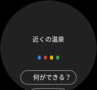
After descending the mountain, you can also use your voice to call up Google and search for day spas
Furthermore, as a smartwatch powered by Google's Wear OS, this model has the potential to be used in a wider range of situations than Garmin, taking advantage of Google's extensive app portfolio, not just for outdoor activities but for everyday use as well. Of course, you can sync the watch with your smartphone to easily view and operate notifications, calendars, weather forecasts, and incoming calls, and some apps even allow you to reply to messages by voice. Other features include voice search, voice input and display of notes, checking news, emails, and calendars, translation, and health management, allowing you to customize your watch to your needs without using your smartphone
Recently, it's become possible to connect to home devices like smart speakers using Google Assistant (although I haven't actually tried it yet). While some have complained about the lack of sensors like a heart rate monitor or thermometer, and the inability to track and analyze more detailed data for athletes, the WSD-F20 offers plenty of functionality and ease of use for beginners and average hikers alike. With the influence of a giant like Google, it's promising that the WSD- F20 's capabilities will continue to expand in the future, with a wide range of apps available, including those for activities outside of the outdoors. If I had to point out a drawback, it would be that it's dependent on third-party apps, for better or worse, and that you need to download the relevant area beforehand to use maps offline.
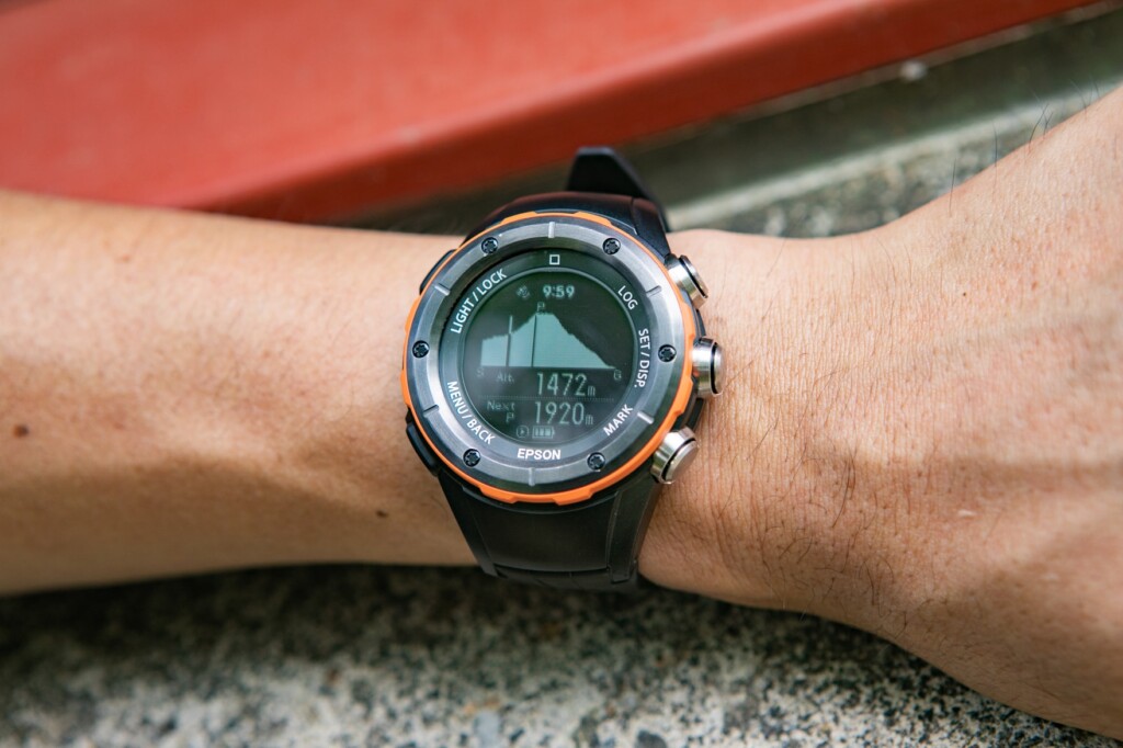
EPSON - Specialized for mountain climbing and running -
Despite its low price, it has sufficient functionality as an outdoor watch for mountain climbing, including a navigation function that allows you to register routes
the MZ-500 offers a wide range of features while focusing on the specific activities of mountain climbing and running . While it has some drawbacks, such as limited support for mountain climbing and running (trail running), a lack of offline maps (and the map display is limited to a rough outline of the registered route), and smartphone connectivity, it offers some convenient features not found on the WSD-F20, especially when it comes to mountain climbing. For example, while recording an activity, you can view detailed real-time data such as your current altitude, distance traveled, and elapsed time, as well as ascent (descent) speed, gradient, and calorie consumption. For running, you can also obtain pitch and stride data. By registering a pre-created route on the device or using a route registered on the device for one of Japan's 100 famous mountains, it can provide navigation in real time with not only the time and distance to your destination, but also "how much climbing remains" (altitude). However, like the Garmin, the accuracy and convenience are lacking, and the effort required beforehand made it hard to actively use. It's still only a supplementary feature, and it seems like it'll be a long way from being fully practical. The dedicated software "NeoRun" that imports tracking data and manages the history after mountain climbing is generally excellent, and it records and compares the activity time, distance, calories burned, number of steps, elevation gain, elevation loss, route, and optionally heart rate. It can also be linked to other apps to some extent, and is probably sufficient for mountain climbing and running.
7. Accuracy: Although there are some quirks, they all have a certain stability that smartphones lack
Now that it's commonplace to know your current location with your smartphone, you might think it's easy to get your current location, but it's not that simple. Regardless of the details of the mechanism, if you want higher accuracy, there are subtle differences in both hardware and software
Since it is difficult to compare the system itself this time, we will summarize the extent of error by comparing the altitude and current location at the same point at various times over the past month, and by later comparing the routes tracked during mountain climbing
In conclusion, there were no significant differences between the three devices. However, upon closer inspection, there were some points that were of concern or should be noted
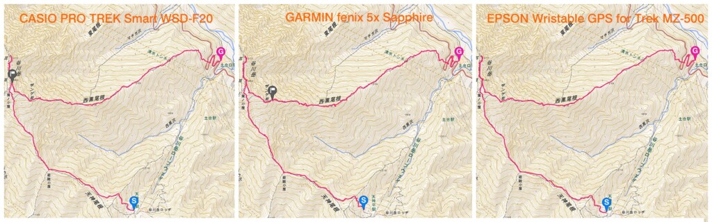
I tried projecting the GPX data tracked by each model onto a 1:25,000 topographical map. It's hard to tell, but Garmin's accuracy is low, or perhaps it's just too high, because the route often strayed slightly from the hiking trail
First, with the Casio, when using YAMAP, the accuracy of the current location and altitude display, as well as course tracking, was quite high, making it the most reliable of the three to check location information. However, when checking the altitude of the original "TOOL" at the same time, it was often off. Of course, it may be possible to improve accuracy by changing the settings, but this shows that it depends on the app, for better or worse
Next up was Garmin. Even with the automatic altitude correction setting, the altimeter was often off, requiring manual correction each time. The current location was prone to slight deviations, and when I checked the track later, it was often slightly blurred compared to the others (see photo above). As a result, the walking distance appeared longer than the other two models (by the way, the distance measurement setting takes slopes into account). Incidentally, I spoke to two friends who use the fenix 5, and they said the same thing happened
Of the three, Epson's readings tend not to deviate significantly, but I don't think it's as accurate as YAMAP
Next page: "Summary - What are the recommendations by type?"
Summary - What are the recommendations by type?
We've compared three representative GPS outdoor watches for mountain climbing from various points of view. As we've mentioned several times in each section, it's not necessarily the case that more expensive models are more satisfactory in every respect, and the outdoor watch that's just right for you will likely be determined by the user's purpose and use (what they want from a watch)
Finally, I'll summarize my recommendations for each purpose based on what I learned from this test drive. In any case, there's no doubt that these are pieces of gear that are so appealing that once you use them, you won't want to let them go. Choose wisely and enjoy the outdoors even more
CASIO PRO TREK Smart WSD-F20
An outdoor watch for everyone, offering a perfect balance of ease of use, convenience, versatility, durability, and accuracy


Simply put, the Casio PRO TREK Smart WSD-F20 is the easiest to use and is recommended for everyone. When it comes to sports watches, models that can perform more specialized measurements, recording, and analysis tend to be popular, but in reality, only a small minority of people are able to use them effectively. If you're using an outdoor watch with these smart features for the first time, I think just want a watch that can view maps anywhere, keep basic records of mountain trips, and generally be stress-free . For such users, this model is perfect.
It's durable enough for outdoor use, has the best map visibility, and is simple and easy to use with a smartphone-like interface. It also comes with YAMAP for mountain climbing and a wide range of other activity apps. It also comes with Google-related apps that are convenient for everyday use, making it a promising device for the future
On the flip side, those who want to get even more out of their sports will likely find the current apps lacking. They can't measure heart rate, pace or stride (when running), don't have a temperature sensor, don't have a long battery life, and don't have dedicated activity management software tailored to the device's capabilities. If you're already a sports watch user and want to push the boundaries, you might be disappointed (for now), so be prepared
GARMIN fenix 5x Sapphire
The best companion for ambitious athletes, recording, analyzing and supporting all the information needed to improve performance
On the other hand, while I had some expectations, the Garmin fenix 5x surprised me with its incredible level of detail. Packed with countless features, thanks to a variety of sensors, including an optical heart rate monitor, and the dedicated performance management and analysis software, Garmin Connect
What's overwhelmingly superior about this watch is its performance measurement and analysis function for running activities. No other model can match this. If you can see your VO2 Max value gradually approaching that of professional athletes through training, there's no better way to maintain motivation for runners who want to improve.
On the other hand, while these features are important for athletes aiming for high performance in races, they may not be so necessary for recreational runners who just want to have fun, or hikers for whom basic navigation and tracking functions are sufficient. To fully utilize these powerful measurement functions, you need to navigate tedious and complicated operations and settings, train hard every day, and even wear the watch while you sleep. It's easy to imagine that users who buy a watch simply for the convenience of offline maps and navigation will be put off by the map display function, which is still in its infancy, and find the watch overwhelmingly multifunctional, struggling with the tedious button operations
What I felt this time was that the reason for the high price is not because it is extremely comfortable to use, but because it is focused on measuring and recording the information that ambitious athletes with specific goals desperately need. For those who can accept this, it will undoubtedly be the best companion worth the price
EPSON Wristable GPS for Trek MZ-500
Recommended for those who want to use the measurement, navigation, and recording functions for long periods of time with peace of mind, especially for mountain climbing and running
I'm looking for a watch that offers all the essential features at a lower cost, even if it doesn't offer the same diverse and complex analysis capabilities as Garmin. Or maybe I don't need the color offline maps and versatility of the Casio, but I want something simpler that provides navigation, measurement, and recording for mountain hikes and races, and I want to avoid worrying about battery life as much as possible. For people like me, the MZ-500 is the perfect choice. Thanks to its monochrome LCD screen, its battery life is particularly impressive compared to the other two . While it only has two modes, trekking and running, limiting it to these makes operation in each mode relatively easy, and the information displayed is simple and easy to read.
As this model was released a while ago, the interface has a somewhat cheap feel to it. However, this comparison shows that it is still not completely worthless when it comes to the detail and accuracy of basic measurement data, as well as various other useful features such as navigation using pre-registered maps. It also has the quality of a Japanese-made watch. This is the cheapest model compared here, and if you limit its use to an outdoor watch for mountain climbing (running), it could be said to be the model with the best cost performance
[Reference] Spec comparison table for WSD-F20, fenix 5x Sapphire, and MZ-500L
*Excerpts from each official website
| Item Name | CASIO PRO TREK Smart WSD-F20 | GARMIN fenix 5x Sapphire | EPSON Wristable GPS for Trek MZ-500L |
|---|---|---|---|
| exterior |  |
 |
 |
| Reference price | 55,080 yen | 107,784 yen | 42,984 yen |
| weight | Approximately 92g | Approximately 98g | Approximately 67g |
| size | Approximately 61.7 x 57.7 x 15.3 mm | 51.0 × 51.0 × 17.5 mm | Φ47mm t=17.6mm |
| Display size | 1.32 inches | 1.2 inches | |
| Display Type | Inorganic glass / Capacitive touch panel (with anti-fouling coating) / Two-layer color TFT LCD (320 x 300 pixels) + monochrome LCD | Sapphire lens / 240 x 240 pixel, transflective MIP color display | Mineral glass (anti-fogging treatment) |
| Touchscreen | 〇 | ― | ― |
| Band replacement | △*Some models have interchangeable bands | 〇 | ― |
| battery | [Without GPS use] (Varies depending on usage environment) Normal use (colour display): Approximately 1 day Normal use (colour display auto OFF*): Approximately 2 days Clock only (timepiece mode): Approximately 1 month or more [With GPS use] (Varies depending on usage environment) Positioning every second (colour display): 6 to 8 hours (accuracy priority) / Approximately 18 hours (battery priority) Positioning every second (colour display auto OFF*): 7 to 9 hours (accuracy priority) / Approximately 25 hours (battery priority) Intermittent positioning (colour display): Approximately 1 day (positioning every 6 minutes) Intermittent positioning (colour display auto OFF*): Approximately 2 days (positioning every 6 minutes) *When not in use, the display will automatically switch to the monochrome LCD clock display. |
Up to 12 days (watch mode + optical heart rate monitor) / Up to 20 hours (training mode + GPS mode + optical heart rate monitor) / Up to 30 hours (UltraTrac mode + optical heart rate monitor) | [When using the watch (Note 1) (Note 2) (Note 3)] Approximately 24 days (when activity tracker is on) Approximately 30 days (when activity tracker is off) [When using GPS] Approximately 46 hours (High-precision mode, GPS positioning every second) (Note 3) (Note 5) Approximately 110 hours (long-time mode, intermittent GPS positioning) (Note 3) (Note 4) (Note 6) (Note 1) When auto sleep is enabled in our environment. (Sleep time: 14 hours/day) |
| GPS | GPS, GLONASS, Michibiki compatible | GPS, GLONASS, Michibiki compatible | GPS and Michibiki compatible |
| Offline Color Map | 〇 | 〇 | ― |
| sensor |
|
|
|
| microphone | 〇 | ― | ― |
| waterproof | 5 atmospheres | 100m | 10 atmospheres (100m) |
| durability | MIL STANDARD compliant | ||
| operating temperature | -10℃ ~ +40℃ | -20℃ ~ +50℃ | -20℃ ~ +60℃ |
| ABC (compass, barometer, altimeter) function | 〇 | 〇 | 〇 |
| thermometer | ― | 〇 | 〇 |
| Sunrise and sunset | 〇 | 〇 | 〇 |
| Activity meter | 〇 | 〇 | △ (only when measuring) |
| Pedometer | 〇 | 〇 | △ (only when measuring) |
| Sleep monitoring | ― | 〇 | ― |
| Bluetooth/Wi-Fi connection | 〇 | 〇 | Bluetooth only |
| Smartphone connectivity | 〇 | 〇 | 〇 |
| Smartphone notifications | 〇 | 〇 | △※Mountain disaster information only |
| Course Navigation | ― | 〇 | 〇 |
| Goal setting | Can be set using the standard app "ACTIVITY" | 〇 | 〇 |
| Waypoint registration | Recording is possible with the standard app "LOCATION MEMORY" | Approximately 1,000 | 100 |
| Distance Record | You can record your hiking adventures using the mountaineering app "YAMAP" | 〇 | 〇 |
| Pace Recording | Can be recorded on "Strava" etc | 〇 | 〇 |
| Altitude Record | You can record your hiking adventures using the mountaineering app "YAMAP" | 〇 | 〇 |
| Location Recording | You can record your hiking adventures using the mountaineering app "YAMAP" | 〇 | 〇 |
| Calorie consumption record | Can be recorded on "Strava" etc | 〇 | 〇 |
| Heart rate measurement | ― | 〇 | ― |
|
Pitch and cadence measurement |
Recording is possible using "Runkeeper" etc | 〇 | 〇 |
| Data and Records Management Services | ― | Garmin Connect | NeoRun |
| Smartphone app | CASIO MOMENT SETTER+ | Garmin Connect app | Run Connect App |
We also recommend this article about GPS watches for mountain climbing
- First Look: Casio PRO TREK Smart WSD-F20: How good is the offline map? I tried it out on a hike
- Review: Tips and tricks for getting the most out of the Casio PRO TREK Smart WSD-F20 outdoors, a camera you'll never want to let go of
- Review: Enjoy the outdoors in winter with the winter-spec Casio PRO TREK Smart WSD-F20X
- NEWS: SUUNTO finally releases a color LCD and touchscreen GPS sports watch. SUUNTO SPARTAN series