購入ガイド:CASIO・GARMIN・EPSON、ぜんぶ試してみて分かった、目的別GPS付きアウトドアウォッチの最適解【後編】
今やスポーツやアウトドアのフィールドで欠かせないギアとなりつつあるGPS付きアウトドアウォッチ。ABC(高度・気圧・方位)機能にとどまらず、現在位置の把握やオフラインでの地図表示ができるなど、ますます進化の一途をたどっています。
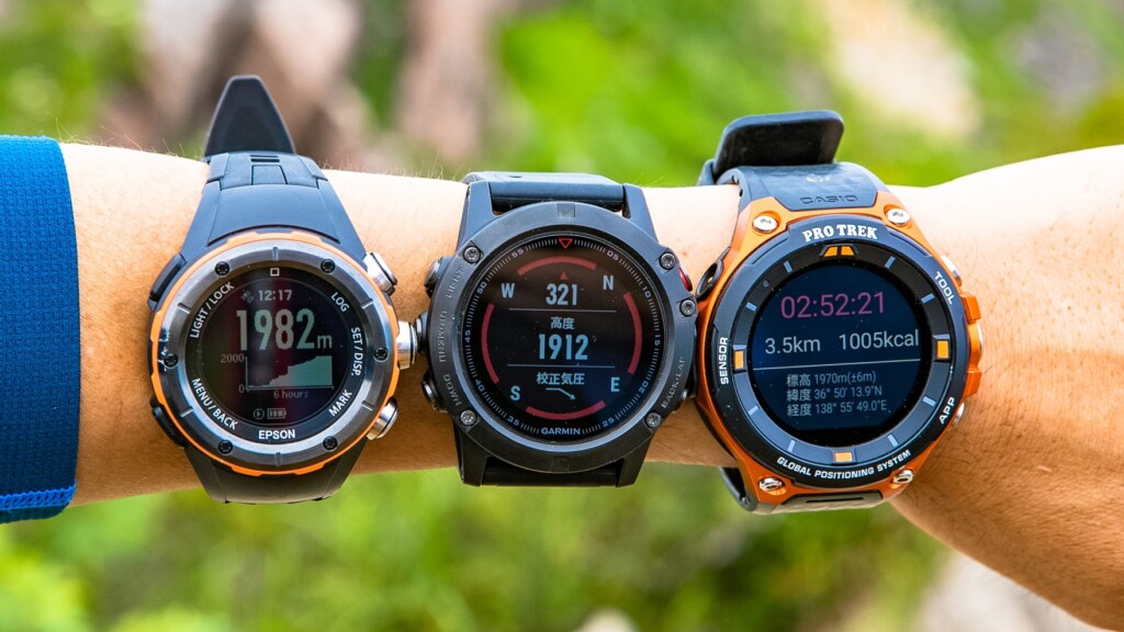
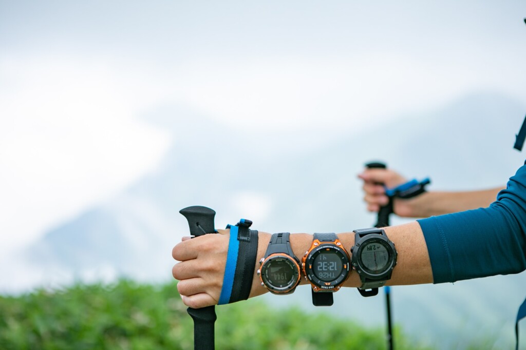
そんなGPSアウトドアウォッチのなかでも、登山での使用も想定してデザインされている代表的なモデル、CASIO PRO TREK Smart WSD-F20 、GARMIN fenix 5x Sapphire 、EPSON Wristable GPS for Trek MZ-500の3つを、実際に登山で同時に使用して比べてみることで、各モデルの特徴と得意・不得意を見てみようというこの企画、今回は後編、日帰り登山で使用して、何がどれくらいできるのかを比べてみたいと思います。ちょうど買おうかどうか迷っていた人に少しでも参考になれば幸いです。
なお、外観やハードウェアの使い勝手についてまとめた前回までのレビューを読みたい方は、以下のページからご覧ください。
目次
- 今回比較試用したアイテムとテスト環境(前編参照)
- 詳細比較レビュー(前編参照)
- まとめ ~タイプ別おすすめは?~(Page2)
- 【参考】スペック・機能比較表
詳細比較レビュー(後編)
6. 機能性・できること
各モデルの機能比較、平たくいうと、この腕時計で「できること」の種類について比較してみます。今回比較した3モデルには、時計・方位・高度・気圧の確認とGPSでの位置情報のトラッキングという基本的な機能については共通しています。ただそこからさらに詳細な領域に入っていくと、それぞれの個性によってできることが大きく違ってきます。もちろんいずれも登山だけのためのデバイスではないため、使う人の目的によって求めている機能は異なるため、印象は人それぞれという面もないわけではありませんが、今回は主に登山・ハイキングに関する機能を中心にして比較・評価していきます。
GARMIN ~アスリートのための強力なフィットネスサポートマシン~
登山前にルートを登録すれば、カーナビのようにナビゲーションしてくれる。
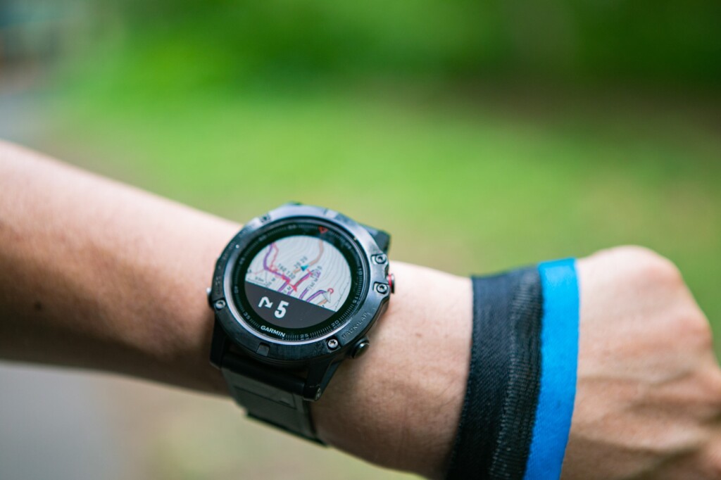
まずは予想通りというか、機能に関していえばfenix 5xの豊富さと細かさはダントツといえます。はっきりいってここでは書ききれないほどあまりにも多くの機能が網羅されているので、ここでは重要な点だけ触れます。さすがはフラッグシップモデルというだけあって、登山やトレイルランはもちろん、ランニング、サイクリング、スイム、カヌー、フィットネス、ゴルフなどさまざまなアクティビティに対応し、光学心拍計を含めた豊富なセンサーによって計測されたデータをそれぞれのアクティビティに合わせて画面上に表示してくれます。しかも表示する内容などもかなり細かくカスタマイズ可能なので、気のすむまで自分流にアレンジできるというのもすごい。オフライン地図はあらかじめ丸々内蔵されているため、事前にダウンロードしておくなどの手間もなく、常に地図が表示できます。あらかじめ作成した登山ルートのGPXデータを時計に送信しておくと、フィールドではまるでカーナビのように役立ってくれます(とはいえ実際の登山で使ってみた感じは、リアルな分岐毎に細かくナビしてくれるほどの正確さはないので、ナビとしてはまだあくまでも遊び)。またスマートフォンと時計を同期させることで、通知、予定表、天気予報、着信等の情報がタイムリーに届けられるなど、いわゆるスマートウォッチ的な使い方も可能です。

ランニングに役立つデータがこれでもかというほど細かく取得可能。
さらに距離や時間・位置情報だけでなく、気温や心拍数の変化、平均ピッチ、カロリー消費量までを詳細に記録し、それらを基にトレーニング効果やVO2Max値(全身持久力・有酸素能力)、乳酸閾値、マラソンの予想タイムまで!分析してくれる、アスリート向け機能は圧巻の充実ぶり。それらは専用管理アプリ「Garmin Connect」で閲覧でき、トレーニング負荷に関するヒントを提供してくれたりと、各アクティビティで記録を伸ばしたい、パフォーマンスを極めたいという人にとってはまさに至れり尽くせりです。
CASIO ~アウトドア向けでもスマホ感覚で気楽に使えて、日常にも便利~
ベースのインターフェースが使いやすいので、優秀なアプリがあると使い勝手は非常に良くなる。
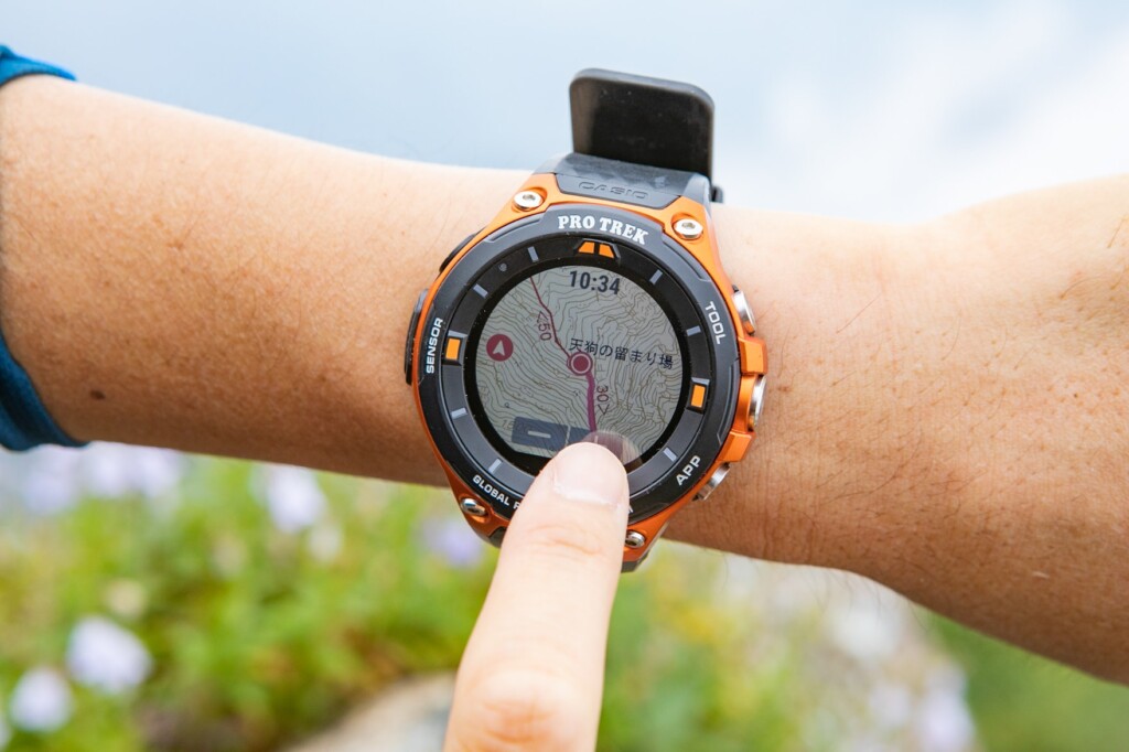
一方、機能の細かさでは敵わないものの、日常使いも含めた幅広さでは決して負けていないのがWSD-F20。まず何より(事前にダウンロードが必要なものの)クリアな表示でオフライン地図が表示できるのはこの価格帯を考えると非常にありがたい。トレッキングだけでなくサイクリング、フィッシング、パドルスポーツ、スノースポーツ、サーフィン、ゴルフなど負けじと幅広いアクティビティに対応した情報表示が可能です。特に日本の登山であればサードパーティ製の「YAMAP」がとにかく優秀。当初不安定な時期もありましたが、今では何だかんだで重宝しています。現地ではコースタイムなどの情報が記載された国土地理院の25000分の一地形図を、オフラインの状態で閲覧でき(事前にネット環境がある状況で転送しておく必要あり)、山行後には自分の歩いたコースをばっちりと記録しておくことができます。普通の登山愛好家である自分的には、機能的にこれで十分といえば十分です。
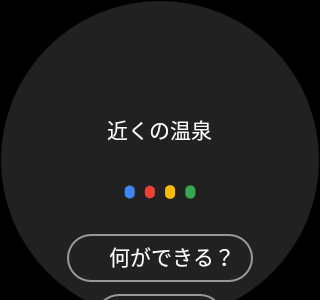
下山後の日帰り温泉も音声でGoogleを呼び出して検索。
さらにGoogleの「Wear OS」を搭載したスマートウォッチであるこのモデルは、アウトドアだけでなく日常を含めてGoogleがもつ豊富なアプリ資産をそのまま活用できるという点で、ガーミンよりも幅広いシーンで利用できる(またその可能性がある)可能性があるといえます。もちろんスマートフォンと時計を同期させて通知や予定表、天気予報、着信等の閲覧・操作はお手のもの、アプリによってはメッセージに対して音声などで返信することも可能です。他にも音声での検索、メモの音声入力と表示、ニュースやメール、予定表のチェック、翻訳、健康管理など、アプリ次第でどこまでも自分に合わせた使い方が、スマホを使わず手元で可能になります。
最近ではGoogleアシスタントを利用してスマートスピーカーなどのホームデバイスと接続することも不可能ではなくなりました(実際にまだ試してはいませんが)。心拍計や温度計などのセンサーは省略されていたり、アスリートにとってはより詳細なデータを駆使したトラッキング・分析ができないという不満がある一方、現状でビギナー~一般ハイカーにとって十分な機能と使い勝手を備え、Googleという巨人の影響力のもと、将来的にアウトドア以外も含めた多様なアプリが充実し、できることがますます拡がる期待がもてるのがWSD-F20の大きな魅力であり、おもしろいところです。あえて難点をいえば、良くも悪くもそのサードパーティ製のアプリ次第という点、そしてオフラインで地図を使用する場合はあらかじめ該当エリアをダウンロードしておく必要がある点でしょうか。
EPSON ~登山・RUN向け機能に特化~
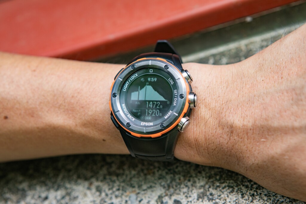
低価格ながらルートの登録によるナビゲーション機能など、登山用アウトドアウォッチとしての機能性は十分。
最後に、登山とランニングという特定のアクティビティに絞ったうえで、多彩な機能を追求したのがMZ-500です。アクティビティが登山とランニング(トレイルラン)しか対応していない、オフラインでの地図がない(おまけに地図表示といっても登録したルートの概略図程度)、スマホとの連携機能などいくつかの不利な点はありますが、登山という点でみれば少なくともWSD-F20にはない便利な機能がみられます。例えばアクティビティ記録中には現在地の高度や移動距離、経過時間だけでなく、上昇(下降)スピード、勾配、カロリー消費量などより詳細なデータがリアルタイムで確認できます。ランニングであればこれにピッチやストライドも取得可能です。あらかじめ作成したルートをデバイスに登録するかもしくは本体に登録されている日本百名山ルートであれば、実際の現場で目的地までの時間、距離だけでなく、「あとどのぐらい登るのか」(高度)をナビゲーションしてくれます。ただこれもガーミンのときと同様、精度や利便性については今一つで、事前に必要な手間を考えると積極的に使いたくなるほどではありませんでした。出来栄えとしてはまだまだあくまでも補助であり、実用に耐えられるようになるにはまだまだ先のことだと思われます。登山後にトラッキングデータを取り込んで履歴を管理する専用のソフト「NeoRun」はおおむね優秀で、行動時間や行動距離、消費カロリー、歩数、上昇高度、下降高度、行動ルート、オプションで心拍数も記録しておき、比較などもできます。他アプリとある程度連携も可能で、登山とランに限って言えば十分といえるのではないでしょうか。
7. 正確性 多少クセがあるものの、いずれもスマホにはない確かな安定性
スマホでの現在地把握が当たり前になった現在、現在地を取得するのは簡単だと思ってしまいますが、事態はそれほど簡単なことではありません。細かい仕組みはともかく、より精度を求めるとなるとハード・ソフト面で微妙な差が出てくるといいます。
今回、仕組みそのものでの比較は難しいため、この1か月のさまざまなタイミングで同じ地点での高度や現在位置を比較したり、登山中にトラッキングしたルートを後から比較することで、どの程度誤差があったかをまとめます。
結論からすると、3つのデバイスで致命的なばらつきはなかったといえます。ただより詳細に見ていくと若干気になるというか、注意すべき点がありました。
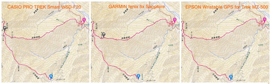
各モデルでトラッキングしたGPXデータを25000分の1地形図に反映させてみた。分かりにくいがガーミンは精度が低いのかはたまた正確すぎるのか、ルートが登山道を微妙に外れることが多々あった。
まずカシオの場合、YAMAPを使用していた場合の現在地と高度表示、そしてコーストラッキングの精度はかなり高く、3つの中で最も安心して位置情報を確認できました。しかし同じタイミングで純正の「TOOL」の高度を見てみると、こちらの方はズレていることがしばしば。もちろん設定の方法によって正確性を高めることはできるのかもしれませんが、その辺は良くも悪くもアプリ次第という点が垣間見られました。
次にガーミン。高度計は高度自動補正を設定しているにもかかわらずズレることが多く、その都度手動で補正する必要がありました。現在地が微妙にズレやすく、後で軌跡を確認してみると他と比べて細かくブレていることが多く(上写真)、その結果、他2モデルよりも歩行距離が長めに出てしまいました(ちなみに距離測定は斜面を考慮する設定)。ちなみにこの傾向はfenix 5ユーザーの友人2人に聞いてもほぼ同じようなことは起こるようです。
エプソンの方は3つの中では特に大きくズレることは少ない一方、YAMAPほどばっちり正確とまではいかなかった印象です。