Can you die without walking? A trip to the US National Parks (5) Recommended hikes in Canyon de Chelly National Monument
Written by Sayaka Kato
Following Sedona and the Grand Canyon, the third recommended hiking spot in the Grand Circle Canyon de Chelly National Monument, .
Located near Chinle, a town in the northeastern tip of Arizona, this scenic spot is surprisingly little known, perhaps because it doesn't get much media coverage in Japan. Although it's small, it's a secret canyon that suddenly appears in the wilderness. It's a place we recommend for those looking for a quiet place with few tourists

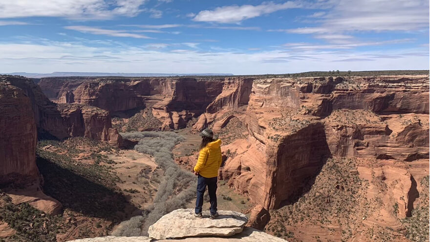
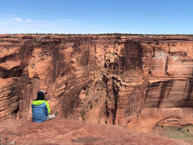
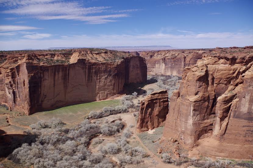
Once you actually set foot inside, you'll be captivated by the unique atmosphere of the land, and the mysterious sight of Native American ruins hidden quietly beneath 300m sheer cliffs. The contrast between the endless, horizontal Colorado Plateau behind it and the canyon that lies hidden here is truly impressive
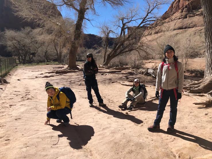
Except for peak periods like summer vacation and the holiday season, there are relatively few visitors, so you can enjoy the Canyon de Chelly landscape at your own pace. You'll be able to fully enjoy the space between yourself and nature
table of contents
Highlights of Canyon de Chelly National Monument
Although Canyon de Chelly National Monument is managed by the National Park Service, which is under the jurisdiction of the U.S. Department of the Interior, the indigenous Navajo people still live within the park, and it is a very unusual place in that it shares the land with the Navajo Tribal Trust Land (Navajo Nation Reservation) and jointly manages the park
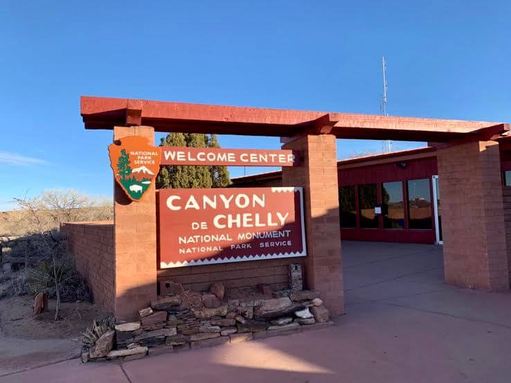
The park is divided into the south side (South Rim) and the north side (North Rim), and you can easily visit all the major viewpoints in one day. You can freely tour the designated observation decks on the south side (South Rim) and the north side (North Rim). To enter the canyon (inside), you will need to join a locally organized tour. There are jeep tours with Navajo driver-guides, and you can make reservations and get information at the visitor center right at the entrance. (The visitor center is located at the junction where the South Rim and North Rim split.)
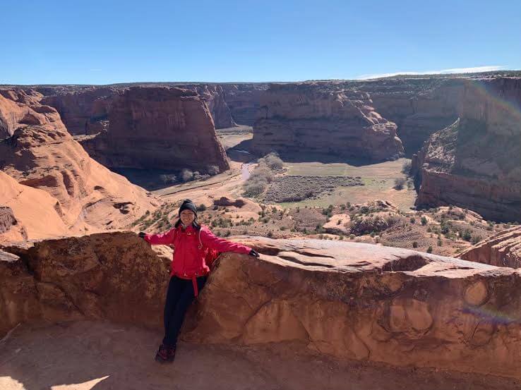
There are many attractions, especially on the South Rim, and the park's most famous sites, the White House Ruin and Spider Rock, are located on the south side. The White House Ruin is the only place where you can descend into the valley on your own without a permit, so we will introduce this trail here
How to get to Canyon de Chelly (rental car)
Travel time
We are located 5.5 hours from Phoenix, 4 hours from Sedona, 3 hours from Flagstaff, 3.5 hours from the Grand Canyon, and 2 hours from Monument Valley
Precautions
There are no petrol stations past the town of Chinle, just before the park, so be sure to fill up here if necessary before entering the park
Best season to hike Canyon de Chelly
It is open all year round from 8:00 am to 5:00 pm (except Thanksgiving, Christmas, and New Year's). Depending on the weather, you can enjoy the viewpoints and hiking all year round. Because it is at an altitude of about 1,670m, it can get cold in the winter and even snow. It can get very cold from winter to spring, so please dress warmly. In the summer, it is very dry and the temperature can get very high. Don't forget to stay hydrated
The recommended seasons for hiking in Canyon de Chelly are from March to early June and from September to the end of November, excluding the busy summer vacation period in the United States
Do I need to go through any procedures before entering the park?
No special procedures are required, and there is no admission fee to this park
What to wear when hiking Canyon de Chelly
Summer
The temperature rises during the day, and the further you go into the valley, the more of a desert climate you will experience. A T-shirt and shorts are perfectly fine. However, there can be windy days, so it may be useful to bring something to wear over your clothes, such as a windbreaker or a fleece to keep you warm
Winter
The altitude itself is about 1,670m, so it gets very cold in winter. Thorough measures to protect yourself from the cold are necessary. Shawls, scarves, and hot packs are also very useful
sunlight
The sun is strong during the day, so be sure to bring sunglasses, a hat, and sunscreen. UV rays can also enter your eyes, so wearing sunglasses when hiking will help reduce fatigue. There are many rocky areas underfoot, so choose sturdy, easy-to-walk-in shoes such as trekking shoes. The weather can change quickly at high altitudes, so it's a good idea to bring plenty of drinking water, rain gear, and snacks. Temperatures can vary greatly between morning and evening, so be sure to always take precautions against the cold when hiking, and be sure to be well prepared
Where are the information centres in the national parks? Can I replenish my food and equipment?
Canyon de Chelly is smaller than the Grand Canyon, so there are no shops or markets within the park. However, the town of Chinle is located very close to the park, and there are gas stations and supermarkets there, so be sure to stock up on drinking water and snacks you'll need for hiking and sightseeing before you go to the park
[Note] There are no gas stations past the town of Chinle, just before the park, so be sure to fill up with gas here before entering the park
Useful items to bring with you on a hike
- Temperature-adjustable winter clothing
- trekking shoes
- hat
- sunglasses
- sunscreen
- Drinks (more in summer)
- Snacks to eat during the hike
- If you have any regular medications, bring first aid such as medicines and bandages
- rain gear
Main attractions of Canyon de Chelly: South Rim
The canyon is about 20km long and about 300m deep. There are paved roads along the canyon and several viewpoints. Among them, the most recommended sights are as follows
White House Overlook *White House Ruins

- Distance: 4km round trip
- Travel time: Approximately 2 hours round trip
This is the most famous ruins in Canyon de Chelly. The buildings built on the bottom of the canyon and on the rock face just above them make the surrounding rock walls even more mysterious, creating a beautiful landscape. This is the only place where you can descend into the canyon without a permit, so be sure to walk the trail to the ruins
At the end of this 2.5 mile (about 4 km) round trip trail is a cave dwelling left by the Pueblo people. It's a very mysterious and mysterious place to imagine that people actually lived there in the past
Apparently, these ruins were built about 1,000 years ago by the Anasazi, the ancestors of today's Pueblo and Hopi peoples, and the name "White House" comes from the fact that the interior walls of this stone house are painted with white plaster. However, the various mysterious stories about the Anasazi that my Navajo friend told me were very interesting, and I simply couldn't take my eyes off the ruins, wondering how such beautiful ruins could have survived
Sliding House Overlook

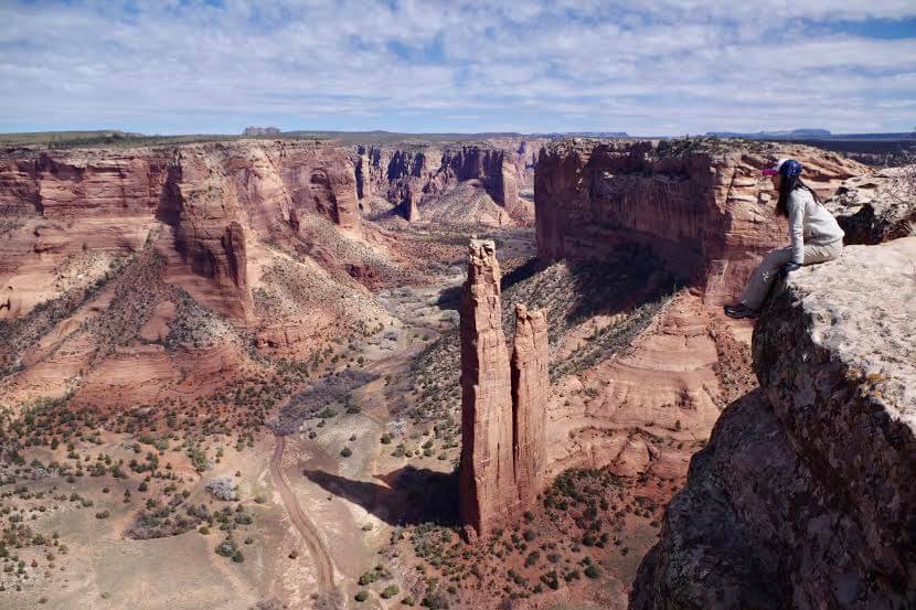
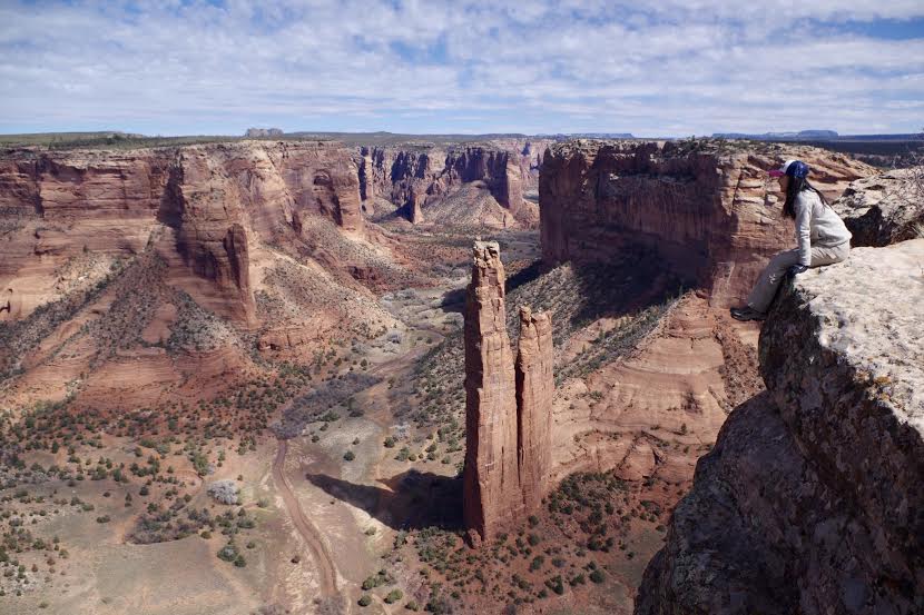
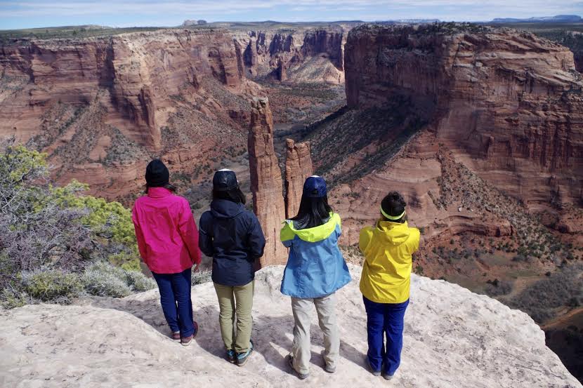
Spider Rocks Overlook
The above two places are also great spots to stop by before or after your hike. They offer picturesque views
The Legend of Spider Woman
As its name suggests, Spider Rocks Overlook features long, spider-like rocks stretching from the ground into the sky. There is an old story about Spider Rock in Navajo mythology, and it is said that a spider who once taught the Navajo people how to weave lives there
A sacred rock rises 244m above the valley floor (2094m above sea level), and in this rock lives Spider Woman, who is still believed to be a goddess by the Navajo people who live here. Navajo children grew up being warned by their parents that if they did something bad, Spider Woman would come down, kidnap them, and eat them on the rock
Spider Woman is an omniscient and omnipotent goddess who created many gods related to the lives of the Navajo people. It is said that the Navajo people were able to learn from Spider Woman the customs of learning, cherishing, and respecting the earth, sun, moon, stars, rain, people, and animals. The Navajo people believe that Spider Woman is an omniscient and omnipotent goddess who created the world
Hiking trail details
Start of hiking
White House Ruin Distance: 4km round trip, elevation difference: 600 feet (about 180m). The trail starts at the parking lot above the valley and descends to the bottom of the valley
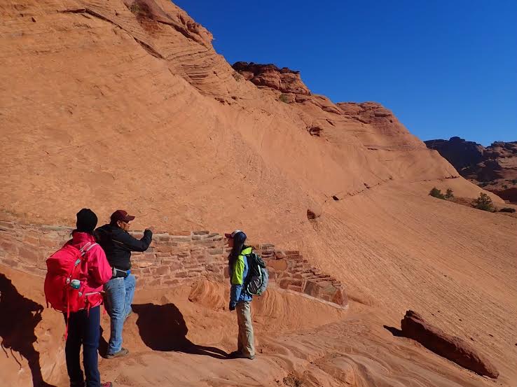
Park your car at the White House Overlook viewpoint parking lot, and the trailhead is located right next to the parking lot. (From the parking lot to the trailhead, walk about 100m along the rim.)
For the first few minutes you walk on rocks, then switchback down. The distance is relatively short at 2.5 miles (4 km) round trip, so if you're in good shape, it's a smooth and easy course. The trail is well-maintained, so you'll be fine as long as you follow the trail
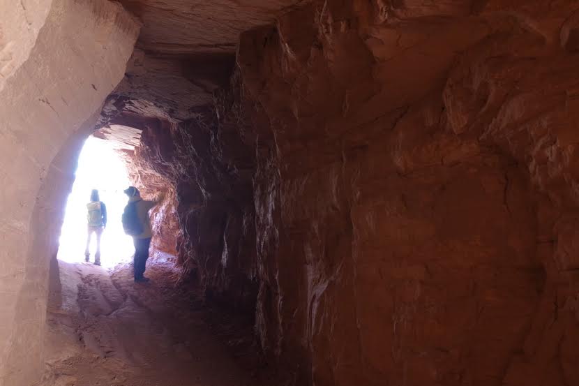
As you continue along the zigzag path, you will come across a tunnel. Going through the tunnel and further down, you will arrive at the bottom of the valley (40 to 50 minutes from the trailhead). There are an abundance of trees growing at the bottom of the valley, and the scenery is completely different from the view from the trailhead, creating a whole new world. Depending on the season, you will also be greeted by beautiful flowers
Because it is a private property, there is a "No Photography" sign at the bottom. There are Navajo people who actually live within the park, so photographing the natives is only permitted with permission and is generally prohibited. (It is okay to photograph the surrounding scenery.)
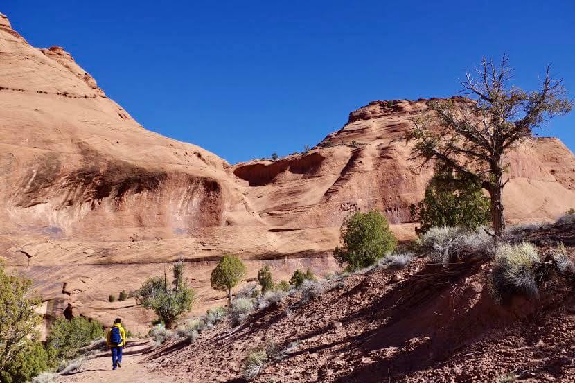
Further along, you'll come across a bridge, but when I went in November it was broken and unusable. The stream that would have flowed under the bridge was also completely dry, with no water. Apparently, it's a stream that only forms when there's a lot of rain. It only becomes a river during the short rainy season, and its water travels 80 miles down to join the Colorado River in the Grand Canyon. When you think about the long, long journey from here to eventually reach the Grand Canyon, it really makes you feel that everything is connected and alive

As we approached the ruins, we saw Navajo people setting up stalls. There were many handmade products lined up, such as Navajo jewelry, rugs, ornaments, and vases. They had a very nice, handmade feel to them. These are the cheapest places to buy things, and you can often find great quality items. This is a great opportunity to buy local products from local people
You can purchase adorable handmade jewelry at very reasonable prices. Be sure to stop by and say hello. You might just find something special just for you
If you walk along the stream in your direction, you will see the White House ruins
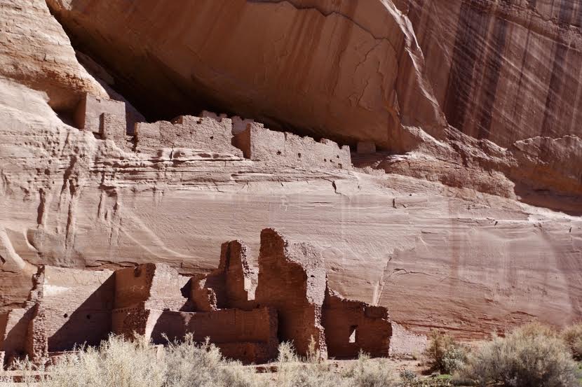
It has been preserved in such a beautiful state that it is hard to stop thinking about how such things could have been made so skillfully so long ago. Please sit in the shade of a tree in front of the ruins and enjoy a short break. Feel the wind and light passing through the valley below, and the atmosphere that surrounds you, and share the space with the Anasazi people who lived there long ago, along with the ruins
To return, simply go back the way you came
This park is a very mystical and beautiful place, even though there are very few people. Major tourist spots that are visited by many people are nice, but this is a particularly recommended place for those who want to quietly face nature and enjoy history, so be sure to check it out
Sayaka Kato
 Leave your Canyon de Chelly hiking adventures to us. Influenced by my father, I've always loved outdoor activities, and while living in Japan, I started hiking and touring national parks, which fascinated me with the natural beauty of America and Canada, ultimately leading me to my dream of coming to America. I currently run ANAMI TOURS, which offers local optional tours created together with our clients, such as completely private hiking tours with Japanese guides. As a local resident, I'm happy to introduce you to special options that I can only learn about. If you're interested, please visit the website below
Related reading
 Can you die without walking? A trip to the US National Parks (6) Recommended hikes in Monument Valley and Navajo Tribal Park
 Can you die without walking? A trip to the US National Parks (4) Recommended hikes in Grand Canyon National Park
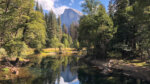 Can't Die Without Walking? A Journey to the American National Parks (1) Beginner-Friendly Yosemite Scenic Trails: Taft Point and Sentinel Dome
 Can't Die Without Walking! A Journey to the US National Parks (11) Point Reyes National Seashore: A Trail Packed with the Best of California