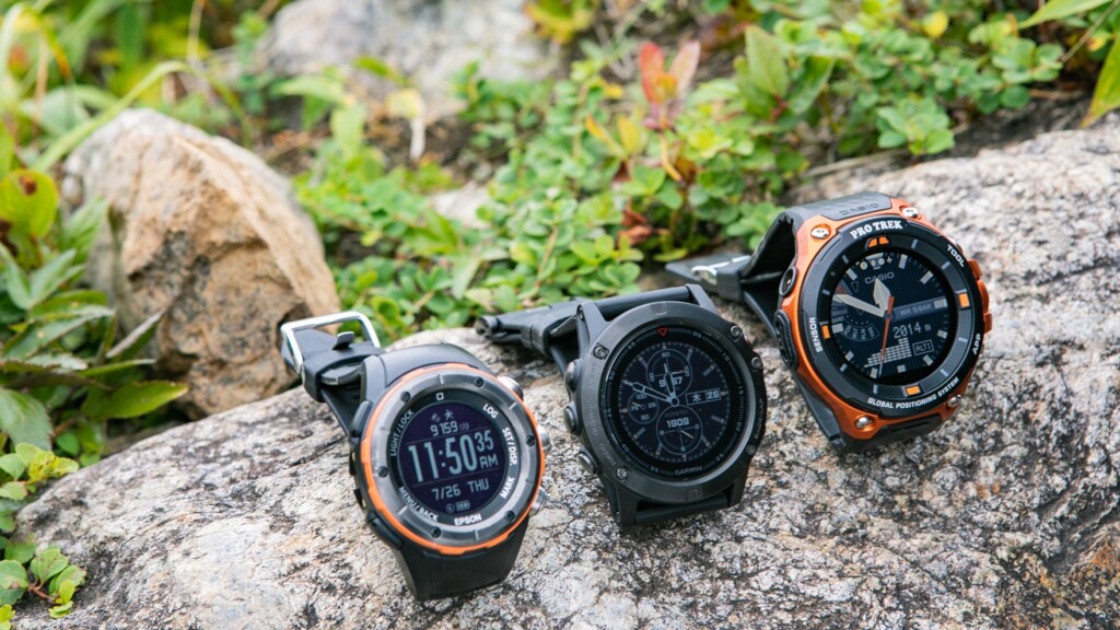
Buying Guide: CASIO, GARMIN, and EPSON: Finding the Best GPS Outdoor Watch for Your Purpose [Part 1]
Written by Yasushi Hisatomi
table of contents
4. Operability and Interface: Once you get used to touch panel operation, everything else becomes a hassle
Outdoor watches not only allow you to look at the time, but also check various information and set functions, so you will need to operate the watch frequently. For this reason, high operability and simple settings are important
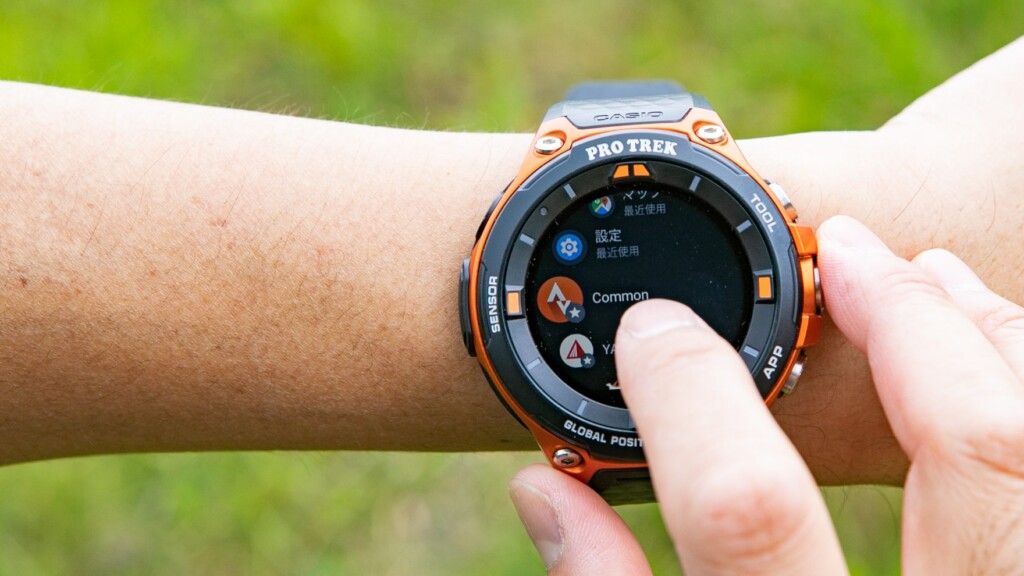
The first thing that stood out in this regard was the WSD-F20 's simple operation with just three buttons and a touchscreen LCD. Of the three buttons grouped together on the right side, the up and down buttons only call up pre-set main functions (by default, they check various sensors and display maps), so essentially all operations are performed using just the middle menu call button and the touchscreen. Of course, this may not be the same for people who aren't used to touchscreens, but in these days when more people are accustomed to smartphone interfaces, this method of operation is sure to be easier.
It can be a bit slow if there isn't enough memory, but operation is smooth and the touch panel is sensitive
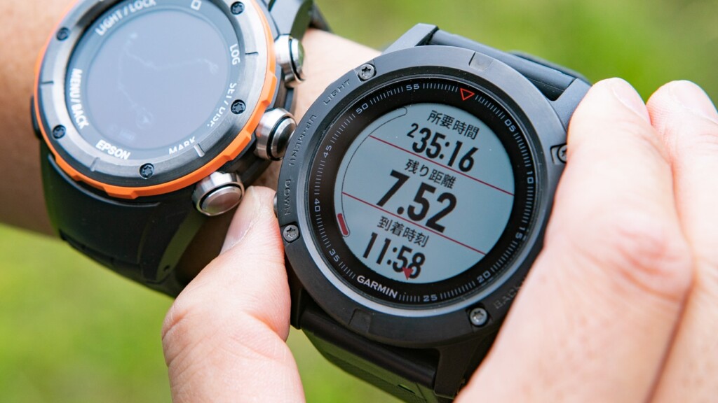
On the other hand the fenix 5x and MZ-500 require you to make various use of the five buttons located on the left and right sides to call up and set many complex functions. Garmin, in particular, makes it difficult to intuitively perform each operation, and you first have to spend time "memorizing" the names of functions, the locations of menus, and each operation. Personally, I find it tedious that you have to perform the habitual operation of "holding down a button" at various times. This is purely a relative opinion, though.
The first hurdle is getting used to operating the buttons located on the left and right
The most notable example was the operation on the map screen. Let's compare them
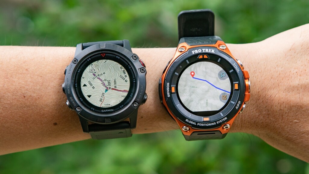
On the left is the Garmin map operation. The left middle and bottom left buttons scroll the map little by little. On the right is the Casio map operation, which can be done with either the touch panel or buttons, making it much easier to operate
The WSD-F20 lets you tap the buttons on the screen (though not shown in the photo, there are "+" and "-" buttons on the screen that you can tap to zoom in and out), and you can use familiar controls like swiping and pinching in and out. the fenix 5x , once you've displayed the map, changing the map's scale requires you to press and hold the menu button, change the scale, and then use the menu (UP) and DOWN buttons to change the scale. Furthermore, to scroll the map, you have to press the top right button again to switch to left/right or up/down movement mode, and then use the UP and DOWN buttons to move the map a little at a time. Overall, this interface discourages you from looking at the map, and I'd like to see some improvements.
5. Battery Life: Epson is strong, Garmin is strong, and Casio is just passing
While the specs give you a general idea of battery life, they're usually just theoretical maximums. What most people want to know is how it performs in real-world usage for specific activities
So, this time, we did a day hike and started the test three times, starting from a fully charged state and checking the battery capacity at the finish line. There were no significant differences in the trends across the three tests, so the table below shows the results of one of the tests: a day hike to Mt. Tanigawa (approximately 6 hours long), with maps and other information frequently displayed
| Item Name | CASIO PRO TREK Smart WSD-F20 | GARMIN fenix 5x Sapphire | EPSON Wristable GPS for Trek MZ-500 |
|---|---|---|---|
| Official specs | 7 to 9 hours (Accuracy priority, Positioning every second, Color display auto OFF) | Up to 20 hours (training mode + GPS mode + optical heart rate monitor) | Approximately 46 hours (High accuracy mode, GPS positioning every second) |
| Battery capacity at the finish line | 36% | 63% | More than 24 hours |
| remarks |
|
|
|
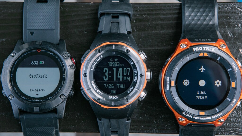
Results from a day hike up Mt. Tanigawa. From the left, Garmin is at 63%, Epson is still almost full, and Casio is at 36%
As for the results, none of them are unusable, but in terms of peace of mind, the MZ-500 's power consumption is astonishing, the fenix 5x does a good job, while the WSD-F20 's power consumption is a concern (although ideally, power consumption could have been reduced further if airplane mode had been turned on to stop unnecessary communications while hiking).
Roughly speaking, the quality of the battery is roughly proportional to the visibility of the screen and the ease of use of the UI. Rather than the quality of the battery itself, it seems that as a result of placing more emphasis on the clarity of the display and ease of operation, the battery life suffers accordingly
the WSD-F20 , which consumes the most battery, has a secret feature that the other two models don't have: it can be used while charging. If you're really low on battery, you can just run the cord from the mobile battery in your pocket directly to your wrist and charge it. *All models can charge while measuring, so more accurately, you can wear it on your arm while it's charging.
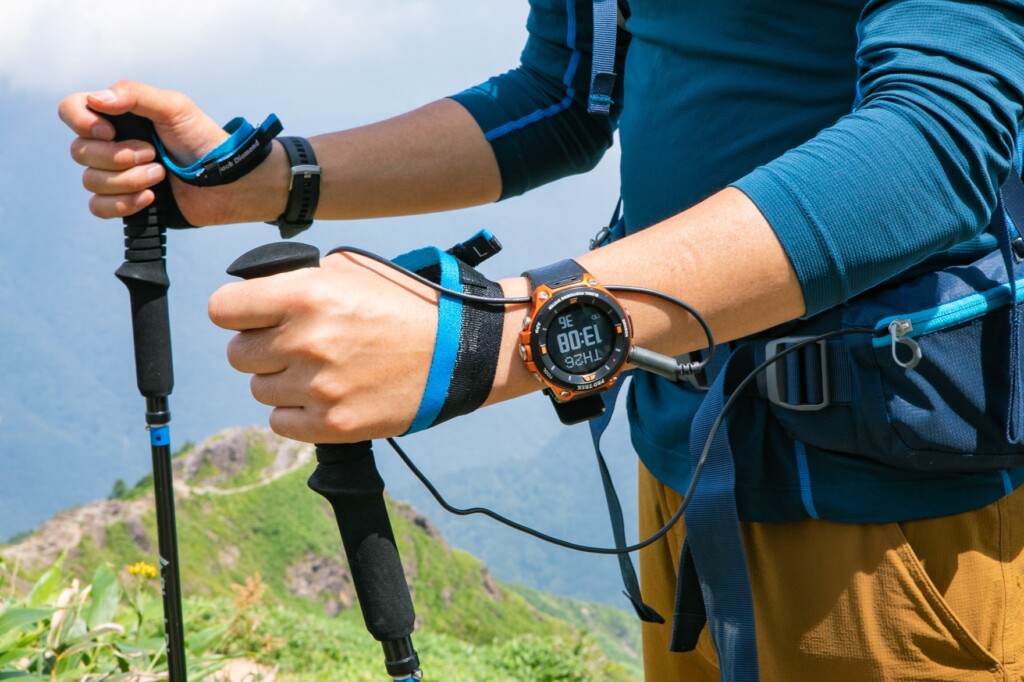
With the WSD-F20, you can put a mobile battery in a hip belt pocket, pouch, or sacoche, and use it to charge your watch while walking
Of course, the manufacturer doesn't particularly recommend it. Personally, I think the extended cord looks unsightly and is prone to getting caught, so I don't recommend it in all situations. However, it recovers a lot with just a few minutes of charging, and recent mobile batteries come in very compact models with high capacity, so I think it's actually a viable method. Above all, it's important to be able to use it as an emergency solution when you really need it
![RAVPower 6700mAh Fast Charging Mobile Battery (Smallest and Lightest as of July 31, 2018) Compatible with iPhone/Android, Portable Charger with iSmart 2.0 Technology, RP-PB060 (White) [18-Month Warranty]](https://images-fe.ssl-images-amazon.com/images/I/41xgZ3XCCRL._SS300_.jpg)
Continued in Part 2
So far, I've written about the first half of this comparison review, focusing on the appearance and overall usability. In the next post, I'll take a deeper look at how well it performs outdoors, such as hiking, and the usability of the app and sensors
⇒ Go to Part 2: "6. Functionality and Capabilities, 7. Accuracy"
[Reference] Spec comparison table for WSD-F20, fenix 5x Sapphire, and MZ-500L
*Excerpts from each official website
| Item Name | CASIO PRO TREK Smart WSD-F20 | GARMIN fenix 5x Sapphire | EPSON Wristable GPS for Trek MZ-500L |
|---|---|---|---|
| exterior |  |  |  |
| Reference price | 55,080 yen | 107,784 yen | 42,984 yen |
| weight | Approximately 92g | Approximately 98g | Approximately 67g |
| size | Approximately 61.7 x 57.7 x 15.3 mm | 51.0 × 51.0 × 17.5 mm | Φ47mm t=17.6mm |
| Display size | 1.32 inches | 1.2 inches | |
| Display Type | Inorganic glass / Capacitive touch panel (with anti-fouling coating) / Two-layer color TFT LCD (320 x 300 pixels) + monochrome LCD | Sapphire lens / 240 x 240 pixel, transflective MIP color display | Mineral glass (anti-fogging treatment) |
| Touchscreen | 〇 | ― | ― |
| Band replacement | △*Some models have interchangeable bands | 〇 | ― |
| battery | [Without GPS use] (Varies depending on usage environment) Normal use (colour display): Approximately 1 day Normal use (colour display auto OFF*): Approximately 2 days Clock only (timepiece mode): Approximately 1 month or more [With GPS use] (Varies depending on usage environment) Positioning every second (colour display): 6 to 8 hours (accuracy priority) / Approximately 18 hours (battery priority) Positioning every second (colour display auto OFF*): 7 to 9 hours (accuracy priority) / Approximately 25 hours (battery priority) Intermittent positioning (colour display): Approximately 1 day (positioning every 6 minutes) Intermittent positioning (colour display auto OFF*): Approximately 2 days (positioning every 6 minutes) *When not in use, the display will automatically switch to the monochrome LCD clock display. | Up to 12 days (watch mode + optical heart rate monitor) , up to 20 hours (training mode + GPS mode + optical heart rate monitor) , up to 30 hours (UltraTrac mode + optical heart rate monitor) | [When using the watch (Note 1) (Note 2) (Note 3)] Approximately 24 days (when activity tracker is on) Approximately 30 days (when activity tracker is off) [When using GPS] Approximately 46 hours (High-precision mode, GPS positioning every second) (Note 3) (Note 5) Approximately 110 hours (long-time mode, intermittent GPS positioning) (Note 3) (Note 4) (Note 6) (Note 1) When auto sleep is enabled in our environment. (Sleep time: 14 hours/day) |
| GPS | GPS, GLONASS, Michibiki compatible | GPS, GLONASS, Michibiki compatible | GPS and Michibiki compatible |
| Offline Color Map | 〇 | 〇 | ― |
| sensor |
|
|
|
| microphone | 〇 | ― | ― |
| waterproof | 5 atmospheres | 100m | 10 atmospheres (100m) |
| durability | MIL STANDARD compliant | ||
| operating temperature | -10℃ ~ +40℃ | -20℃ ~ +50℃ | -20℃ ~ +60℃ |
| ABC (compass, barometer, altimeter) function | 〇 | 〇 | 〇 |
| thermometer | ― | 〇 | 〇 |
| Sunrise and sunset | 〇 | 〇 | 〇 |
| Activity meter | 〇 | 〇 | △ (only when measuring) |
| Pedometer | 〇 | 〇 | △ (only when measuring) |
| Sleep monitoring | ― | 〇 | ― |
| Bluetooth/Wi-Fi connection | 〇 | 〇 | Bluetooth only |
| Smartphone connectivity | 〇 | 〇 | 〇 |
| Smartphone notifications | 〇 | 〇 | △※Mountain disaster information only |
| Course Navigation | ― | 〇 | 〇 |
| Goal setting | Can be set using the standard app "ACTIVITY" | 〇 | 〇 |
| Waypoint registration | Recording is possible with the standard app "LOCATION MEMORY" | Approximately 1,000 | 100 |
| Distance Record | You can record your hiking adventures using the mountaineering app "YAMAP" | 〇 | 〇 |
| Pace Recording | Can be recorded using running and cycling apps such as "Strava" | 〇 | 〇 |
| Altitude Record | You can record your hiking adventures using the mountaineering app "YAMAP" | 〇 | 〇 |
| Location Recording | You can record your hiking adventures using the mountaineering app "YAMAP" | 〇 | 〇 |
| Calorie consumption record | Can be recorded using running and cycling apps such as "Strava" | 〇 | 〇 |
| Heart rate measurement | ― | 〇 | ― |
Pitch and cadence measurement | Can be recorded using the running app "Runkeeper" | 〇 | 〇 |
| Data and Records Management Services | ― | Garmin Connect | NeoRun |
| Smartphone app | CASIO MOMENT SETTER+ | Garmin Connect app | Run Connect App |
We also recommend this article about GPS watches for mountain climbing
- First Look: Casio PRO TREK Smart WSD-F20: How good is the offline map? I tried it out on a hike
- Review: Tips and tricks for getting the most out of the Casio PRO TREK Smart WSD-F20 outdoors, a camera you'll never want to let go of
- Review: Enjoy the outdoors in winter with the winter-spec Casio PRO TREK Smart WSD-F20X
- NEWS: SUUNTO finally releases a color LCD and touchscreen GPS sports watch. SUUNTO SPARTAN series
 Buying Guide: CASIO, GARMIN, and EPSON: Finding the Best GPS Outdoor Watch for Your Purpose [Part 2]
 Review: Garmin Fenix 6X Pro Dual Power This is what we've been waiting for: an outdoor smartwatch that satisfies the desires of all athletes and weekend adventurers
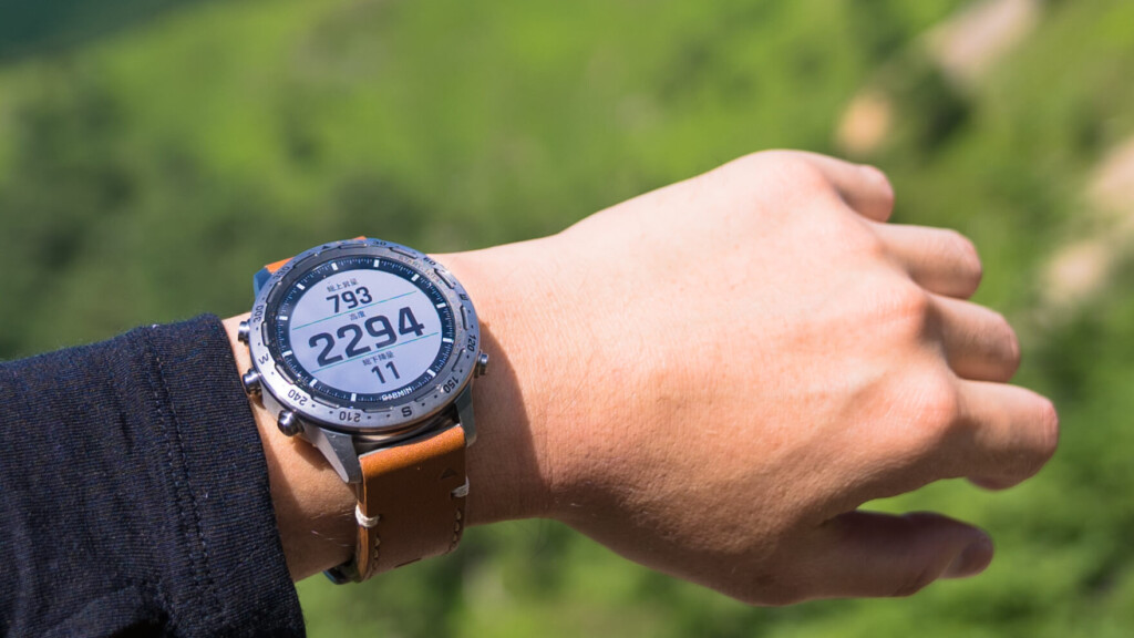 Review: Garmin MARQ Expedition The unique joy that resides in Garmin's premium outdoor smartwatch can't be measured by specs alone
 First Look: CASIO PRO TREK PRW-7000: The "all-rounder" Pro Trek for the avid outdoor enthusiast