Recommendations for Garmin inReach® Mini: Innovative satellite communication devices that everyone entering the mountain should know about
Written by Yoshihiro Murakami
table of contents
Examples of use in Okutama
Let me show you an example how I use it on the Okutama route (counterclockwise). The tracing function is paid, but preset messages are free no matter how many times you send them, so sometimes you walk while sending your current location. Normally, it would be about three nights and four days, but I walked for four nights with a rest.
As explained earlier, my preset message is
- Rest stop. I will go further. --Break, plans to go further
- Lunch time. I rest at least for half an hour. --Lunch time is over 30 minutes.
- Tent here. A good place to spend a night.- A tent here, a good place to spend the night.
It is. This is simplified as L (lunch), R (rest), and T (tent), and fill in the paid message on the map in Photo 20 as $.
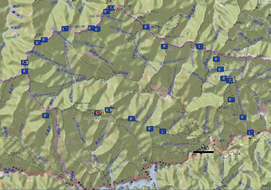
Photo 20: Okutama route, counterclockwise
first day
The preset messages for inReach Mini are L, R, R, and T from Hatonosu Station. After lunch, I received a Have a Good Trip! from a friend. He didn't reply. This is because it costs $0.5. When you receive the product, you will receive a loud warning sound, so you can immediately check the contents on the inReach Mini itself.
We secured 8 liters of water at the water point on Mt. Kawamoshi and set up a tent on the nearby ridge, but it got dark. There were quite a lot of clouds and the weather was bad. After the meal, I tried to send a message to close the day, but my GPS didn't converge and I gave up. It must be because the clouds were thick.
Day 2
The weather had improved in the morning, so I sent a paid message to feel at ease. The content is
Clear sky, slept for a long time, steak of the last night was delicious. I will start in 30 minutes .
It was.
The following preset messages are R, R, R, L, R, R, T. We took a photo of Mt. Fuji at the peak of Mt. Kawamoshi, lunch at Sobakuriyama, repaired a water source with a full water (repairing the off-pipe, fixing the pipe with rocks, stacking the water bucket horizontally, etc.), and arrived at Toritani Hutya at 16:40. It was unmanned so I stayed overnight. The final paid message is
Now, Toritani hut.no one here, started 7:30, Odori-daira 9:00, Mt.Sobatsubu, lunch, 11:00, Ippaimizu 13:30, here 16:40
Now, Toritani hut, there's no one, 7:30 Start, Odori-daira 9:00, Lunch at Soba Ruruyama 11:00, a drink of water 13:30, here 16:40
It was.
Toritani Hut is located on a steep slope and the sky is not very open. It took about 5 minutes for preset messages, and over 10 minutes to send paid messages. I got the impression that Mini's GPS was weak against bad conditions. The old model Explorer takes a little time, but it takes less than 10 minutes.
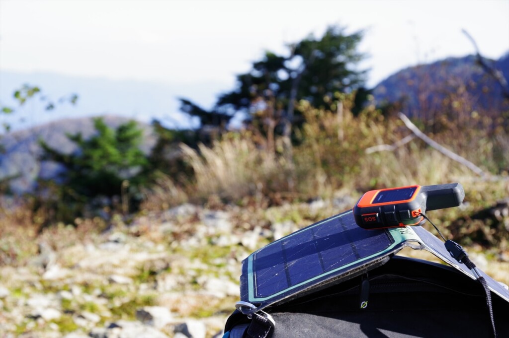
Photo 21: inReach MINI sending preset messages during break
Day 3
The weather and health are getting better, so I'm walking smoothly. The preset messages were R, R, R, L, R, R, T. Lunch was near Imonoki Dokke, and I remember all the ups and downs of Nagasawa Shiryo and passed through without any difficulty. We arrived at Mt. Kumotori Campsite at 14:30. The weather was downhill, and I was able to use my smartphone in the bright lights, but I was out of range in the evening. The message after dinner is
Now Mt.Kumotori campsite : started 7:00, Mt.Nagasawa10:15, lunch 12:10, Mt.Imonoki-dokke 13:00, here 14:30
It was. It was also a hassle to send this message. When clouds arise, GPS position calculation seems to be delayed.
Day 4
The weather was cloudy, windy and cold. The preset messages were R, R, and T. The summit of Mt. Kumotori was out of range, and Mt. Fuji was only visible, making my motivation less powerful, and from Mt. Nanatsuishi, Takamaruyama passed through the makita road. We set up a tent at the Takanosuyama campsite around noon. The final paid message is
Mt. Takanosu campsite: started 7:30, Mt. Kumotori, slight view of Fuji, Alternative trail of Mt. Nanatsuishiyama, here 11:50
Now, Takanosuyama Campsite starts at 7:30, only a few Mt. Fuji is visible, Mt. Nanatsuishi is a makita road, here 11:50.
I couldn't think of the English word for "mocking" so I decided to use another path, but since it's not very well-structured, it doesn't seem that bad. I secured 8 liters of water, took a nap and spent the tent until after dinner. According to the radio, it rains at night. There was no one in the shelter, so I put away the tent and moved in.
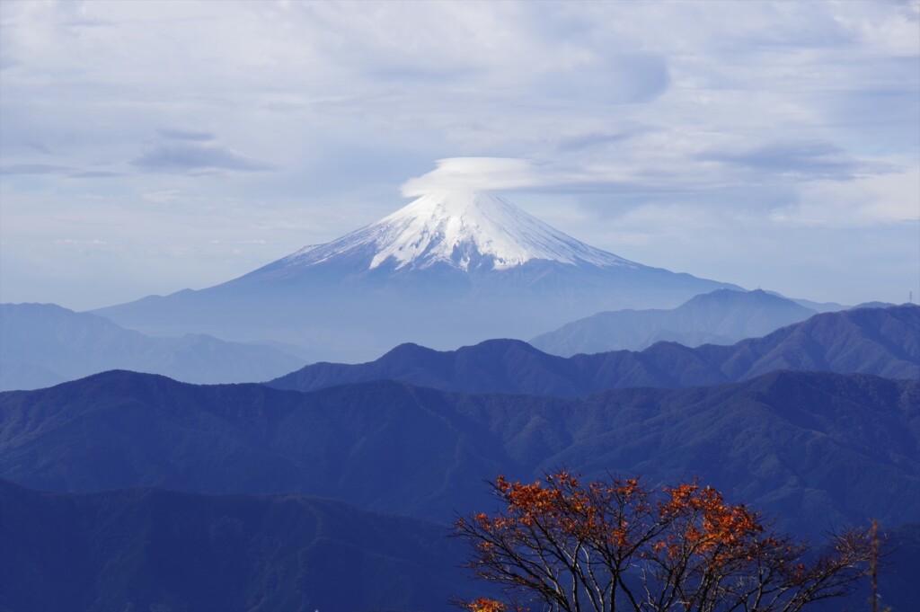
Photo 22: I waited an hour for the clouds to disappear, but the clouds remained.
Day 5
On the final day, we took a picture of Mt. Fuji at Mt. Takanosu, and then we just went down the road. The preset messages were R, R, R, L, R. There was no need for paid messages, but the weather was on the rise. So I waited an hour at Mt. Takanosu and took a photo of Mt. Fuji. Because you should not be worried about it,
Waiting for a clear view of Mt.Fuji. cloudy, rained at night
, waiting until Mt.Fuji looked beautiful, it rained last night
I sent it. After finishing the stone ridge, we had lunch and from here we were within the distance of our smartphone. Send R near Okutama Town. We made it possible to confirm that we arrived safely.
Feelings of use of inReach Mini
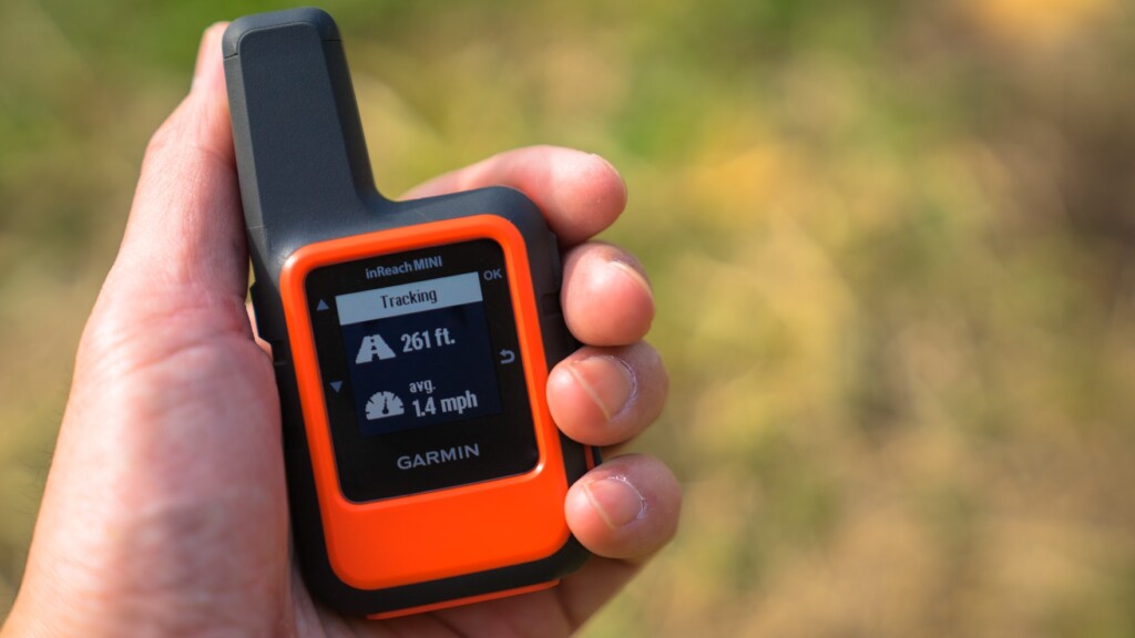
The inReach Mini is a small 100g case packed with iridium satellite communication devices and GPS devices. The screen is small and the display is simplified. The GPS performance is not that high.
If you use the old model of Explorer, the message "3D" will appear when the GPS position calculation is complete. If you know the iridium satellite and are in communication, two-way ⇅ will be displayed. So, you can understand that communication will end after a short wait.
However, in inReach Mini, you cannot tell whether GPS position calculation has finished unless you switch to the Location screen in the menu. Also, unless you return to the top screen, you won't know if you've grasped the Iridium satellite. This is Photo 23. It's still inconvenient.
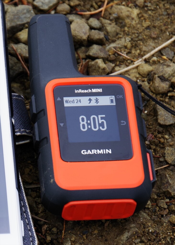
Photo 23: When GPS position calculations are finished and communication with the iridium satellite, a bent upward arrow will be displayed. After a while, the transmission will be successful
GPS devices grasp three or more GPS satellites, use the slight time difference in radio waves from them to calculate their current position, and use the provisional position to calculate their own calculations repeatedly to reduce errors. Considering that the current position has converged when this error is within the acceptable range.
The Mini built-in GPS works quickly in sunny weather. The position error is very accurate at about 1 meter. However, the speed of position calculations is significantly reduced when cloudy or in forests. The GPS unit may not be very sensitive. Anyway, I will not try to finish the position calculation until an accurate position is calculated.
In fact, I always carry a standalone GPS called the Map64s. This GPS is extremely excellent, and calculates the current position in 10-20 seconds after power is turned on and displays the map. They successfully calculate the location in the forest, on trains and buses. Garmin's independent GPS is a strategy where even if there is an error of around 100 to 200 meters, it displays the current position for now, then corrects the error in 1 to 2 minutes, and suppresses the error to about 1 meter. It's a bit rough, but practical.
InReach Mini and the old Explorer do not consider the position calculation to be completed until the exact location is determined using GPS. I feel the difference between strategy, or calculation philosophy. It seems they don't like sending inaccurate location information. DeLore was absorbed by Garmin about two years ago, but I got the impression that DeLore still exists independently within Garmin.
Explorer + can display maps, but it is assumed that it is far from the Garmin Map64s based on GPS performance and location calculation algorithms. Standalone GPS such as the Map 64s also has the advantage that you can download free topographic maps from around the world from GPSFileDepot (https://www.gpslepot.com/). For the time being, it would be more advantageous to use both standalone GPS and inReach Mini.
When GPS does not converge
What should I do when the GPS location calculation doesn't converge and I can't send an email? Since Mini is mostly aware of the iridium satellite, it is best to ignore the GPS and send an email. In other words, if you can't send an email no matter how long it takes, leave your smartphone as is.
- Turn off the inReach Mini and then turn it on.
- If you are sending a message, the Wait for GPS and Send Anyway selection menu appears.
- Select Send Anyway.
If necessary, make this choice to resolve the problem. If the message is being sent, resetting your smartphone will not cause the message to be lost. In my experience, I think that turning on inReach before creating a message on a smartphone increases the chances of successful transmission.
When did it help?
Let me explain some of the experiences that I have had incredibly useful.
The water filter is broken
In August 2012, while walking south from Yosemite on the John Muir Trail, the water filter pump broke after passing Muir Pass. The water in America is not clean, and I want to drink fresh water, which was very troublesome. Fortunately, I was with the Japanese hiker for a while, so I borrowed a water purifier for the day. I was planning to meet my wife at the bishop and meet up. So we sent in to secure a water purifier through inReach.
The Bishop has a large mountaineering equipment store, but there is no guarantee that it will always be in stock. I had a water filter secured by the time I arrived. This was the first generation inReach. At this time, I ignored my location information and sent it, so I apparently was in Africa.
The camera is broken
I retired in July 2015, so I stayed in Pinedale for two months and hiked Winds. When I went on my second hike, the autofocus on my SLR didn't work. Manual focus was possible, but it was inconvenient. So I sent an email to my Japanese wife on inReach asking me to send an alternative camera. When I returned to the hotel after my second hike, another SLR was waiting for me.
After the first hike, I happened to have successfully hitchhiked and got in the car. However, it was on the rough road at Winds's number one, and my body was jumping up and down in the car. At this time, the autofocus part of the lens broke, and the camera itself was on the verge of collapse, and after a while it stopped working. However, thanks to the alternative models, we were able to take many spectacular views of Winds. This is also thanks to the first generation of inReach. It is common for American regional cities to have no camera shops.
Muscle rupture
In August 2017, I was walking northward along the John Muir Trail. It was a record-breaking snowy year, and I avoided going to the cross country and did quite a bit of cross country. Perhaps that's why the muscles in my legs were tired. As soon as I jumped over the stream and landed on the rock on the other side of the bank, I felt a great deal of pain in my left foot. I later learned that it was a torn calf muscle.
It was still south of Mother Pass, and it was two nights and three days away from Bishop. So I met my wife and planned to walk the loop trail, which includes the Muir Pass. It was a very difficult task, but taking painkillers made me feel painless and I was able to walk. I was contacted inReach and was late due to a leg injury. In the end, my wife extended my stay at the motel for about three days. I couldn't get much strength in my legs on the climb, so I arrived at the Bishop a day late.
I had internal bleeding in my leg, so I gave up on the loop trail and went on a two-night, three-day round trip hike to Bishop Pass. My legs recovered in about a week and walked to Yosemite. The device used at this time was the inReach Explorer, and I'm still using it today.
I didn't press the SOS button. A muscle rupture is because only a few muscles are broken and you can walk by taking painkillers. If it's an Achilles tendon, SOS will be inevitable.
To sum up
GPS of inReach Mini has the drawback that GPS converges slowly under adverse conditions. However, if the weather is good, the location information is accurate. If the GPS does not converge, two-way communication using iridium satellites is possible anywhere. The cost of the equipment is around 40,000 yen, and if operated on a one-year contract it costs $12 a month. It weighs 100 grams. To be honest, there's no reason not to use it.
Do not press the SOS button on the inReach Mini unless you are in a desperate situation. If you're in a difficult situation, you can simply send an email to an acquaintance and try to overcome the situation, even without using the SOS button. Currently, there are very few Japanese users of inReach, so I have disclosed my experience and how to use it.
It is not uncommon in mountains in Japan that it is missing and it takes a week or two to search. If the search takes a long time, it won't help anyone who will save them. However, this kind of thing can be prevented by installing inReach Mini. I hope that tragic disasters will disappear in Japan.
In addition, I borrowed inReach Mini from Outdoor Gearzine and got the opportunity to write a review. I would like to state that I am simply an old user of inReach and have no interest in Garmin.

[Addendum from the editorial department] As mentioned earlier, in addition to the basic usage explained here, I have written a new article about more practical usage. If you are interested, please also refer to the following article:
Murakami Nobuhiro
 Born in 1950. Currently, he is a professor emeritus at Toyama University. His specialty is educational psychology and educational measurement. His outdoor-related works include "The Complete Collection of Outdoors" (Sanichi Shobo), "Outdoor Tools: The World of Backpacking" (Shunjusha), and "Hiking Handbook" (Shinyosha). In terms of psychology, there are also some such topics: "Psychological Tests Was a Lie" (Nikkei BP), "What Can Psychology Understand?" and "Intellects to Be Defeated" (Chikuma Shobo). His recent works include "American Hiking Encyclopedia" (Ai Publishing), which compiles the know-how of the author who has been hiking numerous American long trails every year, including the Glacier, the John Muir Trail, and Winds.

Related reading
 Practical use of Garmin inReach, a accessible satellite communication device, when hiking - two-way messaging, how to link with Facebook, etc.
 Goodbye Garmin inReach. Welcome au Starlink Direct
 Review: Garmin MARQ Expedition The unique pleasure that resides in Garmin's finest outdoor smartwatch, which cannot be measured by specs alone.
 Review: Garmin Fenix 6X Pro Dual Power I've been waiting for this. Outdoor smartwatch that satisfies the desires of all athletes and weekend adventurers